
Wildfires have long been a part of California’s natural landscape, but few recent disasters have matched the scale, speed, and devastation of the Eaton Fire of January 2025. Sparked in the foothills of the San Gabriel Mountains and pushed by intense Santa Ana winds, this fire rapidly evolved into a fast-moving catastrophe that destroyed thousands of structures, displaced entire communities, and reshaped the social, economic, and environmental future of the region.
This 3,000-word article provides a complete, in-depth overview of the Eaton Fire—its origins, spread, emergency response, human impact, environmental toll, legal consequences, and what this disaster means for the future of wildfire preparedness in California.
- Introduction: What Was the Eaton Fire?
The Eaton Fire was a major Southern California wildfire that ignited on January 7, 2025 near Eaton Canyon, a popular recreational and wildlife area just north of Pasadena and east of Altadena. Within minutes, winds carrying burning embers pushed the flames downhill into residential neighborhoods.
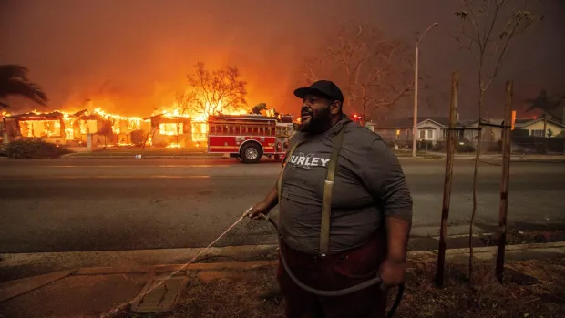
The fire burned for 24 days, consuming more than 14,000 acres, destroying over 9,400 buildings, and becoming one of the deadliest residential fires in California’s history.
The Eaton Fire quickly entered national headlines due to:
the sheer scale of destruction,
the speed at which neighborhoods were engulfed,
the failure of emergency alert systems,
and the questions surrounding utility responsibility.
It stands today not only as a natural disaster but also as a case study in infrastructure vulnerability, climate-driven fire behavior, and emergency management under pressure.
- Where and How the Eaton Fire Started
2.1 Location of Ignition
The fire began near:
Eaton Canyon Nature Center
Canyon Close Drive
Northeast Altadena foothills
This location is known for its:
dense shrubs (chaparral),
steep ridges,
dry canyon vegetation,
and proximity to power transmission lines.
2.2 Initial Reports
The first fire report came at around 6:18 p.m. PST. Within less than ten minutes, firefighters reported:
active flames,
erratic fire behavior,
and embers blowing roughly 1 mile ahead of the fire front.
These conditions aligned with the strong Santa Ana wind pattern that developed early that week—warm, dry, and gusty winds moving from the desert toward the coast.
2.3 Eyewitness Accounts
Residents reported:
loud arcing sounds near power lines,
sudden bursts of sparks,
and a “wall of fire” descending from the canyon.
Videos circulated online showing bright flashes along transmission lines seconds before the flames erupted—fueling speculation that electrical infrastructure played a central role in ignition.
- Day-by-Day Timeline of the Fire
January 7, 2025 — Day 1
Fire ignites at dusk.
Within an hour, ember storms cause spot fires throughout Altadena.
Helicopter water drops are attempted but canceled due to violent wind turbulence.
First evacuations begin, though alerts fail to reach thousands of residents.
January 8 — Day 2
Fire spreads rapidly into neighborhoods.
Over 500 structures burn by early morning.
Emergency shelters open across Los Angeles County.
January 9–10
Fire reaches peak intensity.
Strong winds push flames toward the city border of Pasadena.
Thousands more evacuated.
State of emergency declared.
January 11–14
Cooler nighttime temperatures slow the spread slightly.
Firefighters focus on saving critical infrastructure and hospitals.
January 15–20
Winds calm.
Fire becomes more predictable.
Containment lines strengthened.
January 21–31
Firefighters gradually gain control.
Final containment reached on January 31.
- Total Damage and Scale of Destruction
The Eaton Fire’s destruction was unprecedented for an urban-interface fire in the region.
4.1 Burn Area
14,000+ acres scorched
Canyon, foothill, and suburban zones devastated
4.2 Structures Lost
9,418 structures destroyed
1,071 structures damaged
Residential neighborhoods such as:
East Altadena
Lower Eaton Canyon communities
Mountain View Estates
were hit the hardest.
4.3 Deaths and Injuries
At least 17–19 confirmed fatalities
Over 400 injuries, including:
smoke inhalation,
burns,
trauma from evacuation accidents
4.4 People Displaced
Tens of thousands forced to evacuate
Thousands left homeless
4.5 Economic Losses
Preliminary assessments estimate:
Billions of dollars in structure loss
Millions in firefighting resources
Long-term economic impacts on tourism, real estate, and local businesses
- Why the Fire Spread So Quickly
5.1 Santa Ana Winds
These desert winds are:
hot,
dry,
fast-moving (up to 60+ mph).
They:
supercharged the fire,
carried embers long distances,
and made firefighting aircraft unsafe.
5.2 Dry Vegetation
Months of drought left:
chaparral,
oak woodlands,
dried grasses
extremely flammable.
5.3 Canyon Terrain
Steep slopes act like:
“chimneys,” funneling wind and flames uphill or downhill at high speed.
5.4 Ember Storms
Burning embers landed on rooftops, vehicles, backyards, and dry brush—igniting dozens of spot fires simultaneously.
- Emergency Response: What Worked and What Failed
6.1 Firefighting Agencies Involved
CAL FIRE
Los Angeles County Fire Department
U.S. Forest Service
Local municipal departments
Over 3,500 firefighters were deployed at peak activity.
6.2 Challenges Faced
Winds too dangerous for aircraft
Nighttime visibility issues
Narrow canyon roads prevented quick equipment movement
Heat and smoke limited ground access
6.3 Failure of Emergency Alerts
One of the most controversial aspects:
Thousands of residents never received evacuation alerts.
Some alerts were delayed.
Others went to the wrong neighborhoods.
This led to:
preventable deaths,
last-minute escapes,
and confusion across the region.
- Human Impact: Stories of Loss and Survival
7.1 Families Who Lost Everything
Entire households were reduced to ash:
photo albums,
heirlooms,
vehicles,
decades of savings,
family businesses.
Some families returned to find nothing left but:
a chimney,
a mailbox,
scattered debris.
7.2 Emotional and Psychological Trauma
Survivors reported:
anxiety,
insomnia,
PTSD symptoms,
grief over lost loved ones,
uncertainty about rebuilding.
Community centers continue to provide counseling.
7.3 The Devastation of Altadena’s Historic Neighborhoods
Altadena is culturally significant:
one of Southern California’s earliest historically Black communities,
rich in jazz, arts, and civil-rights history.
Entire blocks of heritage homes burned.
- Environmental Impacts
8.1 Wildlife Loss
Eaton Canyon hosts:
deer,
bobcats,
coyotes,
mountain lions,
numerous bird species.
Many animals:
died,
lost habitat,
or migrated permanently.
8.2 Soil Damage and Erosion
When vegetation burns away:
roots no longer hold soil,
mudslides and flash floods become likely.
This puts nearby communities at risk during winter rains.
8.3 Air Quality Crisis
Smoke blanketed:
Los Angeles County,
Inland Empire,
parts of Orange County.
Major pollutants included:
fine particulate matter (PM2.5),
toxic ash,
chemicals from burned homes.
8.4 Water Contamination
Burned runoff can pollute:
rivers,
reservoirs,
groundwater.
- Was Southern California Edison Responsible?
9.1 Power Line Investigation
While official investigations take time, early findings suggested:
arcing or sparking from power lines may have ignited nearby vegetation.
Multiple lawsuits argue:
SCE failed to properly maintain its equipment,
ignored wind risk warnings,
did not shut off lines despite dangerous conditions,
allowed deterioration in high-risk areas.
9.2 Company Response
Southern California Edison:
acknowledged a possible role,
expressed sympathy,
but denied negligence.
9.3 Legal Actions
Victims filed:
wrongful death lawsuits,
property damage claims,
class-action suits.
Government agencies may seek reimbursement for firefighting expenses.
- Rebuilding and Recovery Efforts
10.1 Short-Term Aid
Residents received help from:
FEMA,
Red Cross,
state relief funds.
Support included:
temporary housing,
food assistance,
debris removal,
cleanup grants.
10.2 Long-Term Rebuilding Challenges
Reconstruction faces obstacles:
insurance disputes,
rising construction costs,
loss of documents,
strict building codes in fire zones,
emotional trauma.
10.3 Community Support
Volunteers organized:
donation drives,
meal distributions,
pet rescue efforts.
Neighborhood groups launched rebuilding campaigns.
- Lessons Learned from the Eaton Fire
11.1 Infrastructure Must Be Modernized
Aging electrical systems pose:
wildfire risks,
community harm,
billion-dollar liabilities.
11.2 Evacuation Systems Need Upgrades
The Eaton Fire proved:
alert systems must be faster,
multilingual,
geographically accurate,
tested regularly.
11.3 Climate Change Intensifies Fires
California’s:
hotter summers,
earlier dry seasons,
stronger wind events
create explosive fire conditions.
11.4 Home Hardening Is Essential
Improving home safety through:
ember-resistant vents,
fire-resistant roofs,
defensible space,
brush clearance
helps reduce destruction.
11.5 Community Preparedness Saves Lives
Disaster readiness must include:
emergency kits,
evacuation plans,
backup communication methods.
- The Eaton Fire’s Place in California History
The Eaton Fire joins the list of major wildfire disasters, alongside:
Camp Fire (2018),
Tubbs Fire (2017),
Woolsey Fire (2018),
Dixie Fire (2021).
What made the Eaton Fire unique was:
the number of structures lost,
the dense suburban impact area,
the failure of alert systems,
and the role of utilities in wildfire ignition.
- Conclusion
The Eaton Fire of 2025 was more than a wildfire—it was a tragedy that exposed deep vulnerabilities in:
infrastructure management,
emergency preparedness,
climate resilience,
forest and land maintenance,
and community support systems.
It left behind:
thousands of destroyed homes,
grieving families,
displaced communities,
damaged ecosystems,
and enormous financial loss.
But it also sparked crucial conversations about:
how to prevent future fires,
how to build more resilient communities,
and how to strengthen emergency systems for the next generation.
The Eaton Fire is a reminder that in a warming climate—where drought and wind events are increasing—California must evolve to protect its people, its homes, and its natural landscapes.